


Du col au lac vert

Alfredy
User GUIDE
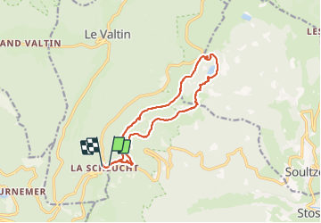

Length
16.1 km

Max alt
1283 m

Uphill gradient
529 m
Km-Effort
23 km

Min alt
1049 m

Downhill gradient
558 m
Boucle
Yes
Creation date :
2014-12-10 00:00:00.0
Updated on :
2014-12-10 00:00:00.0
5h32
Difficulty : Difficult

FREE GPS app for hiking
 SityTrail
IGN / Geographical institutes
SityTrail Plus
The world is yours!
About
Trail Walking of 16.1 km to be discovered at Grand Est, Vosges, Le Valtin. This trail is proposed by Alfredy.
Description
Très belle randonnée réalisée avec 2 familles mais il faut compter un peu plus de 6 heures avec enfants avec 1 heure de pause.
Positioning
Country:
France
Region :
Grand Est
Department/Province :
Vosges
Municipality :
Le Valtin
Location:
Unknown
Start:(Dec)
Start:(UTM)
352813 ; 5325353 (32U) N.
Comments